The Rio Grande Valley (RGV) is bracing for a series of significant weather transformations in the coming days. While the region is accustomed to hot and semi-arid conditions, an approaching cold front promises to bring changes that could impact both daily life and the environment. Meteorologist Maria Perez has highlighted these weather fluctuations, emphasizing the potential hazards and necessary precautions residents should take.
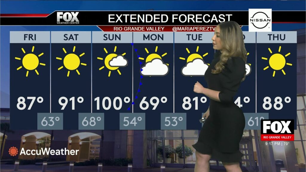
This weekend is set to see a dichotomy of weather patterns, with scorching temperatures followed by a rapid drop as a cold front sweeps through the area. These conditions underscore the complexity and unpredictability of weather in the RGV, a region characterized by its proximity to the Gulf of Mexico and the Rio Grande River.
The RGV, comprising cities like McAllen, Brownsville, and Harlingen, is experiencing a mix of weather conditions that are not only raising temperatures but also increasing the risk of hazardous phenomena such as rip currents and drought. Understanding and preparing for these environmental changes is crucial for local communities.
Current Weather Conditions
Presently, the Rio Grande Valley is experiencing clear skies with cooler evening temperatures, stabilizing around 67 degrees Fahrenheit. Easterly winds are blowing across the region at 11 miles per hour, providing some relief from the day's heat. Despite these mild conditions, the weather is anticipated to take a dramatic turn in the coming days. The National Weather Service has issued a Small Craft Advisory for the coastal areas from South Padre Island to Port Mansfield, cautioning against high seas and dangerous rip currents which may pose risks to mariners and beachgoers alike.
Hazards and Public Safety Measures
Hidalgo and Starr counties are particularly affected by severe to extreme drought conditions, necessitating an Outdoor Burn Ban effective until June 8th. This ban aims to prevent fires by prohibiting the burning of trash, yard waste, and other combustible materials. With the dry conditions, any spark could lead to uncontrollable wildfires. Therefore, it is imperative for residents to follow the guidelines and abstain from any activities that could cause fires.
Beach safety is also a priority, with the risk of rip currents at locations like South Padre Island being a significant concern. Swimmers are advised to stay within designated swimming areas, heed warnings signaled by red flags, and know how to escape rip currents by swimming parallel to the shoreline, not against the current.
Anticipated Changes and Weather Precautions
The anticipated cold front set to arrive late Sunday and into Monday heralds a sharp temperature drop. While daytime temperatures could rise to a sweltering 100 degrees Fahrenheit on Sunday, they are expected to plummet to around 54 degrees by the night. Monday will see a high of only 69 degrees, with nighttime temperatures maintaining a cool 50s range. Residents should prepare for these swings by adjusting their outdoor plans and dressing appropriately for cooler temperatures.
The coming days are a stark reminder of the region's vulnerability to rapid weather changes. Meteorologists are urging the public to stay informed through local news channels and weather updates, and to make necessary adjustments to their daily routines. Special attention should be given to vulnerable populations such as the elderly and young children who are more susceptible to the effects of drastic temperature changes.
Additional Resources
For continuous weather updates and advisories, residents and visitors are encouraged to visit the National Weather Service.