As the weekend approaches, residents across South Texas are gearing up for sunny skies and higher temperatures. With spring break in full swing and families making plans for outdoor barbecues and beach trips, it's the perfect opportunity to enjoy the warm weather. Forecasts indicate that temperatures will soar to the low-to-mid-90s in various cities throughout the region, with a general trend of humidity and wind gusts offering a hint of cooler sweetness to an otherwise sultry weekend.
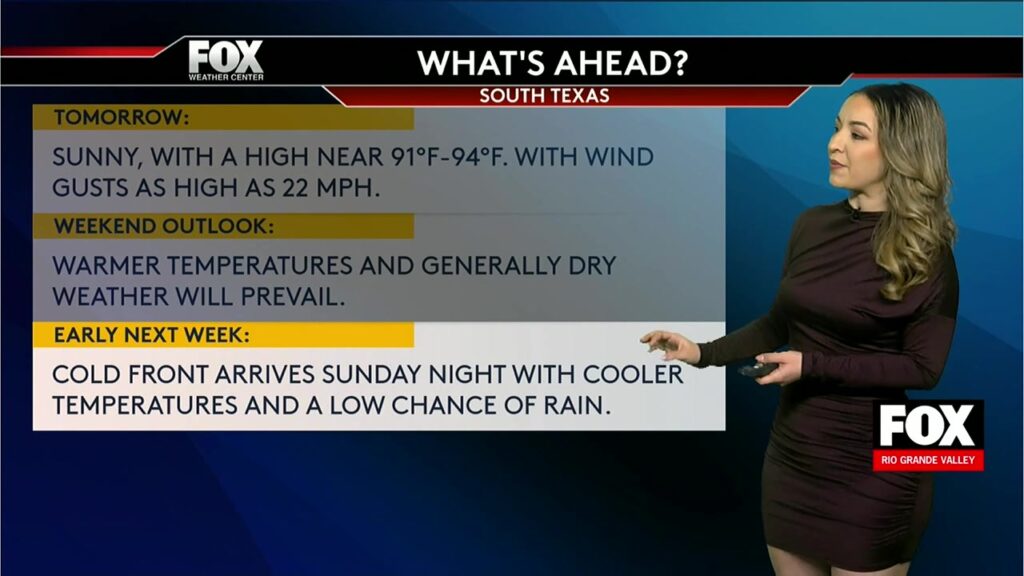
This region of Texas, known for its vibrant culture and proximity to the Gulf Coast, often experiences a unique blend of weather patterns. From Laredo to South Padre Island, residents can expect a few surprise turns as the weekend progresses into early next week. Despite the warm forecast, a cold front on the horizon towards Sunday evening promises to bring some respite in the form of cooler temperatures and the possibility of rain.
Forecast Predicts Sunny Days and Strong Winds
With the weekend looming, weather forecasts are giving residents of South Texas a heads-up about what to expect. High temperatures will range from 91 to 94 degrees Fahrenheit, and winds are expected to gust up to 22 miles per hour. These strong winds may especially affect beach outings and outdoor events, so caution is advised. While sunny skies are a welcome sight for many planning to head outdoors, it's important to prepare for the challenging wind conditions.
Laredo and Zapata are expected to see slightly higher temperatures, inching into the mid-to-upper 90s. In places like Corpus Christi and Harlingen, the temperatures may vary as sea breezes play a cooling role near the coastline. Meanwhile, inland areas like Edinburg and McAllen might feel the heat more acutely, encouraging residents to stay hydrated and seek shade during peak afternoon hours.
Weekend Activities and Safety Tips
The South Texan weekend scene promises an array of activities ranging from beach outings on South Padre Island to cultural festivals in cities such as Brownsville and McAllen. With Spring Break in the air, these coastal regions will likely draw significant crowds, both locally and from neighboring states.
When planning outdoor activities, safety remains paramount. The high temperatures coupled with strong winds increase the risk of fire hazards, so fire safety precautions at barbecues should be strictly adhered to. It's recommended to keep a water source nearby when grilling and to ensure that all grills are positioned away from flammable materials.
For those venturing to the beaches, the coastal winds may escalate the risk of rip currents. Swimmers are advised to stay vigilant, keeping within designated swimming areas where lifeguards are on duty. Always heed warning flags and advisories posted at beaches, and monitor children closely in the water.
Looking Ahead: Cold Front to Bring Change
As we move from weekend leisure into the working week, the presence of a cold front on Sunday night into Monday is likely to alter the weather dynamics. This front is predicted to bring scattered showers and possibly reduce temperatures significantly, offering relief from the spring heat.
The cooler temperatures might result in a more comfortable setting for early week activities. Residents are advised to prepare for fluctuations in weather and to keep an umbrella handy as rain showers could vary in intensity.
This colder onset could potentially affect road visibility and lead to localized flooding in areas with poor drainage. It's crucial to stay updated with real-time weather reports and heed any advisories issued by local authorities.
Additional Resources
For more detailed and updated information, residents can refer to local government and weather websites, such as the National Weather Service in Corpus Christi and Hidalgo County's official website. These resources provide timely updates on weather conditions, safety advisories, and emergency information that is vital for staying safe and informed.